York Tramways
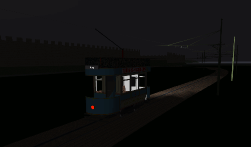
The last tram heads back into town from Haxby Road
Background
York [England] had a small horse-tram system from 1879–1910, and a six-route electric system from 1910–1935. I’ve modelled the track network as it was at its fullest extent (about 14km), from 1916 onwards. The six routes are:
- Fulford — basically the same as the original horse-tram route, with a depot on the site of the horse depot at Fulford Cross. At the city end, cars crossed Ouse Bridge, then turned right to head to the station via Rougier Street rather than head up the steep hill of Micklegate, which gave so many problems to the horse-cars.
- Hull Road — cars ran out along Walmgate, through Walmgate Bar, and terminated at the Bee’s Wing Hotel.
- Haxby Road — the original terminus was just short of the bridge over the ner goods branch to Foss Islands (the ner-dvr link); in 1916 the route was extended to Rowntree’s. The city end of the line connected to the Railway Station via Gillygate, Bootham Bar and Lendal Bridge
- Dringhouses — cars from the station ran out via Queen Street onto The Mount and Tadcaster Road, terminating a little short of the modern Askham Bar park-and-ride.
- Acomb — cars turned off The Mount and ran to Acomb via Holgate Road, serving the railway works. This route ran in isolation for a while when the system first opened, as there was a delay in laying tracks over the Holgate Road railway bridge.
- South Bank — cars coming from the station ran straight ahead down Nunnery Lane, then out along Bishopthorpe Road to terminate in Queen Victoria Street, serving the racecourse and the new Terry’s works. (This route also served the old Terry’s site in Clementhorpe.)
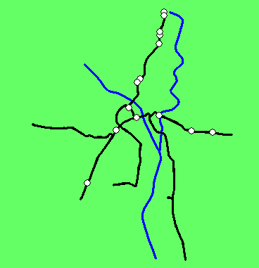
Basic route network + rivers
For comparison, have a look at this map of York ca. 1940 (from os one-inch New Popular Edition maps). This gives a good idea of the limited extent of the various suburbs during the tramway era.
Operation
The main interest for the moment is in playing with document scripts (cf. Types Of Script) for setting routes and destination indicators. As can be seen from the layout map above, it’s either shift-change at Rowntree’s or I haven’t got it quite right yet…
The script uses a lot of constructions like this in the OnReverse() part to set the routes of departing trams to a predetermined series:
		if(Location=="Dringhouses")
		{
			counter1++;
			if(counter1==1)
			{
				Train.SetRoute("F");
				Train.SetDestinationIndicator("Fulford");
			}
			if(counter1==2)
			{
				Train.SetRoute("HU");
				Train.SetDestinationIndicator("Hull Road");
			}
			if(counter1==3)
			{
				Train.SetRoute("HA");
				Train.SetDestinationIndicator("Haxby Road");
				counter1=0;
			}
		}
A major issue I still have to resolve is getting the trams neatly in and out of the depot. For the moment, the routing script switches over at midnight to assign the cars to route “X” (Depot). A timetable sets the departure for this route to 6 am. A separate signal script assigns departing trams to different routes.
The problem with this is that all the cars want to leave the depot at the same time. One possibility would be to use another signal script to assign trams arriving at the depot to different routes with departure times in the order they arrive (e.g. first five cars get X1 dep. 07:00, next five get dep. 06:40, and so on).
Trams
First attempt at a York tram - this is essentially a rebuild of the existing “Brush_OT” model. Also note the improved bracket mast. Still a few things to do, e.g. adding proper controls.
Scenery
Not much yet, and it will be tricky to get enough buildings for a real city feel without killing the framerate (problem with all tram layouts). I’ve added the rivers and sketched in the city walls.
Resources
- Barry M. Marsden, York tramways and Trolleybuses, Middleton Press 2006 (includes car drawing by Terry Russell)
- Comic postcard of the York horse-tram on the tlrs site. This image gets reproduced whenever the York trams are mentioned in print…
MRG 26/06/2013 14:49:08